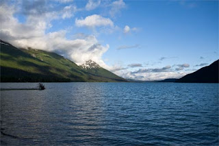
It was a very cool 48 degrees when we packed up and left the Kenai Peninsula on Saturday about noon. Before leaving we stocked up on cases of canned king salmon which we were able to stow in the trailer. After a stop at Costco in Anchorage we were back in the Mat-Su Region and camped at Matanuska Glacier State Recreation Site. We had visited this site before when we were based in Palmer but it was not nearly as nice, from a weather perspective as Saturday. John captured this-
On Sunday morning we left camp about 6 am and headed to Tok, the first town when you come into Alaska from Canada. John found a campground, Tok River Recreation Site, just a few miles outside of town, but more importantly, close to the Taylor Highway which leads to Chicken. Our goal was to get to Chicken in time for lunch and we had to cover about 350 miles from our starting point. On the drive up the Tok Cutoff road we saw this pair of trumpeter swans which John captured on his camera.
It only took about 10 minutes to set up camp and leave at noon for Chicken. On the drive up the Taylor Highway the road was washed out last Saturday when over 10 inches of rain fell between the communities of Chicken and Eagle. It actually washed away one car and the driver hasn’t been found and about 35 campers, motor coaches, trailers and cars were stuck, with the latest 40 foot motor coach getting out yesterday. That caused us not to be able to go back into Canada over the “Top of the World” road.
On Monday we knew we had a hard week of driving before us if we wanted to be in Victoria Island over the weekend, so we decided to leave every day by 6 am and stay in the Yukon Government Campgrounds and the British Columbia Provincial Parks.
As we left Alaska on the Alcon Highway, four moose bid us farewell –a bull, 2 cows and a yearling. They were too far away to photograph, but we watch through the binoculars and John saw one cow chase the others away from the water. Of course, I missed that because I was trying to find my binoculars…
In the Yukon Territory, we drove through Destruction Bay and just had to capture this image of their police car. There are only 55 people who live there and it is just s beautiful area by Kluane Lake, which is the largest lake in the Yukon Territory, so I’m sure there are a lot of speeders, and no police. What a hoot!
We have been traveling on the Cassiar Highway, or as John refers to it, “the highway from hell” from Watson Lake south through the western part of British Columbia. It is a 463 mile road—half of it in terrible shape and half in just above poor shape. The interesting thing is there are no communities in this part of the province that are more than a couple hundred people, but there are tons of lakes, streams and beautiful scenery. We got to the Yellowhead Highway yesterday and today got onto the West Access Route to Alaska which will be our route until we get back into the US.
As we left the Yukon Territory, John captured this one last photo of a black bear eating the flowers on the side of the road. Haven’t seen any more bears since this one.
On the 20th we stayed at Boya Lake which was beautiful, but it started to rain and that weather system has been with us through our stay on the 21st at Seeley Lake Provincial Park and even some today.
We have seen foxes, red and black. John says the black ones are very rare. There were two at this gravel pit, but of course, never close enough together to get a decent shot.
This morning we passed through a little community, Burns Lake, with about 10,000 population throughout the area and at both ends of town they have what John refers to as the “Flower power slug bugs” and he captured this one.
We’ll leave tomorrow and be in the Vancouver area until Monday, and we plan to stay in the Provincial Parks so there will be no more internet postings until Monday.
Mileage to date 10,939.


